
Demolition begins this Monday, March 6, 2017 to remove the 4-foot concrete warehouse foundation (AKA Sugar Pad) for the Intermediate Terminal and Riverfront Public Access Project.
The second phase also includes grading, seeding and refurbishing the Terminal Dock, and is expected to be completed by June. At completion the dock will be ready to receive cruise ship traffic.
Ahead of Phase III, as part of the Riverfront Master Plan, a public meeting will be scheduled in the near future to present conceptual options for the Terminal Dock and Lehigh Property. The improvements at both the Terminal Dock and Lehigh properties are expected to provide public park space and public riverfront access.
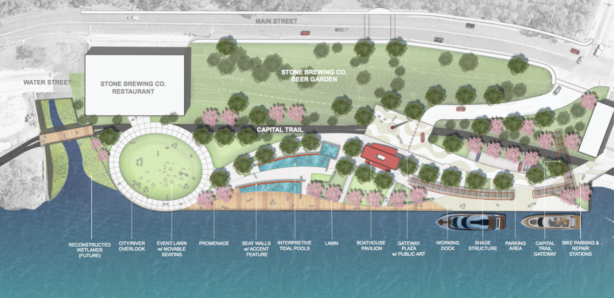
A conceptual plan from 2015 (ABOVE) (LARGER) illustrates a much more polished version of the area, connecting a dock area to a public promenade in front of the planned Stone Brewing Restaurant.
[sep]

[sep]
PHOTO (Sugar Pad): Google Maps April 2014
53 comments
FB_10210217862070687
FB_10103945329654796
FB_10158443625935533
FB_10211524474522468
FB_10209853184585047
FB_10105037497686113
FB_10208773730884757
FB_10154809893149439
FB_10207275869566182
FB_10100469124911749
FB_10154910832050196
FB_1528534177160811
FB_10208772080327277
FB_593567467507042
FB_10103039594051508
FB_1524635930884585
FB_355281578164934
FB_10202668046299955
FB_1206119449424292
FB_1198377293591382
FB_1186772208096344
FB_10211271375485166
FB_1846836388908051
FB_10154846943941742
FB_10208955846635058
FB_10104927205507587
FB_1538597029493340
FB_10206679424464886
So wharf street is closing? Traffic diverted to main?
this link takes you to the most recent planning concepts for the site (above rendering is very old)
http://www.richmondgov.com/PlanningAndDevelopmentReview/documents/PlansRiverfront/2016_1115_Downriver_presentation_KR.pdf
Awesome, thank you!
I sure hope they can demolish this without closing Wharf STreet!
Cruise ship traffic?! How awful! Just think of what that will do to the river!
Noooooooooooo
More pollution of every kind. Almost makes me regret the years of work done by so many to save and get people to this area.
Sure will be terrible to see someone do something nice with that abandoned industrial site.
Why turn it into something nice when we could just refurbish it as more parking?
Who doesn’t want to visit a nice parking lot?
Its my understanding that cruise ships dump sewage and waste in international waters because, somehow, there is no law for that to be against.
How is it that they will be polluting the James? Please educate me, if anyone knows. Generally I’d like them to come to Richmond, support our economy, and not pollute. How do we get that?
@5 & @10 – There is no way for cruise ships to come to Richmond. The James is not deep enough for their draft. The ships illustrated here are of similar size to those docked 100 yards down river at Rocket’s Landing. There are also several bridges that would not have the clearance needed for cruise ships.
It’s a non-issue.
River boat cruise ships. Not ocean cruise ships. Yes, it’s A Thing.
sewerage in the river comes from your house via the city CSO. so where is the public outrage to fix that?
Come on guys…..have any of you every actually been on the river in a boat?? The James is a WORKING river. There are tons of working boats on it. Ocean going vessels travel to Deep Water Terminal all the time. Tugs push barges all over the place. There’s mining operations every where and DuPont, Phillip Morris, and bunches of industrial plants have docks. And the further you go south the busier it gets.
And YES…. Cruise ships do indeed dock in Richmond. Not Ocean vessels but ships like Viking River Cruises do. And no…..A ship cannot just dump its sewage in the river….jeeezzz! Seriously??
And most of the CS overflow has been fixed. It’s only during periods of intense rain does sewage flow into the river. We’ve had amazing progress with fixing the James. Give me a break….
Calm down people. I bet most of you did not realize that right across the river from Libby hill and rockets landing is the main
Richmond Wastewater Treatment Plant. And that little spillway that dumps into the water, right across from Rockets, where do you think that water is coming from?
For yall newbies to Richmond, they are talking about a river boat cruise ship like the “Annabel Lee” that used to dock at Sugar Pad. These are just smaller river boats that do cruises on the James.
@ Jessica Shook and Dubious2
FYI, The whole length of sugar pad is about 750 feet and the width of the James river right there is about 500 feet wide. So NO, No, NO a 1200 foot cruise ship that yall are IMAGINING in your heads would never be on this part of the James River.
@Dubious2, need more education?
Sorry, had to add this. Google map the “Richmond Wastewater Treatment Plant” across from Rockets (or Conch). Look at the spillway from the plant where it dumps “clean” water into the river. You can almost see the turds floating by…
Anyone want to petition City Council to ban all motorized boats on the James — at least this side of the Port of Richmond — that are run by fossil fuels? Electric motors would be OK but gas and diesel powered ones would be out. Jet skis would also be banned under this proposal.
Just wondering…………….
the CSO/no part of the CSO has never been fixed. just a bunch of half-assed tinkering
Oh course it’s river boat cruises, just like the Annabelle Lee that used to dock here. My goodness, what a lot of panic!
@ray, the City Council has very little if any jurisdiction over a navigable river. The dock at the sugar pad is a working, industrial dock. Tugboats and barges and river cruise ships and dinner cruise ships use it. It’s pretty cool that goods can arrive this way instead of only by trucks. Farther downriver you’ll see cargo ships heading to and leaving from the Port of Richmond terminal. You can kayak and go see it for yourself. There’s a lot more to the river than what you see from Libby Hill.
Thanks, Juliellen, but as a longtime “river rat” I think I know just about every nook and cranny (yea, a bit of an exaggeration) on both sides of the James from Bremo Bluff to Hopewell.
My question in #17 is simply asked out of curiosity, not advocacy.
Sign, only on CHPN would I see announcements about a park turn into complaints about added pollution..
The problem is the people on the hill act as if they are the only ones with a vested interest in the city and the only ones who pay into the tax base
Anyone have any photos of this with the building still on it? It really wasn’t that long ago that it was demolished but I’ve totally forgotten what it actually looked like.
Thanks if you have any to share!
The history of this soon-to-be-waterfront-park is really interesting. It was an important location for Cuban sugar imports before the early Castro-era Cuban embargo ended that trade and together with it the vitality of this location. The vacant economic pause this dock has had since those days represents the end of the times when small ocean-going tramp steamers could bring stuff straight from across the world to small inland ports like ours. Now global trade is conducted on monstrous container ships that disseminate cargo by barges to ports like ours downstream.
The resurgence of small ship river cruising along the lines of Viking cruises is a great opportunity for this waterfront to be relevant in the scale it was intended – busy with small ships – and also amplify the Capital Trail, the James River Park System, the waterfront in general.
The adjacent brew pub use should also tickle the historians up here – a branch of the Yuengling group operated a steam brewery in Rocketts in the late 19th Century.
Gentle readers here in the neighborhoods should use this opportunity to urge the City to connect us – our Church Hill, Chimborazo, Oakwood and Fulton neighborhoods – to this location by dedicated, safe walking and bike trails. Waterfront visitors walking and cycling up the hills are exactly the kind of visitors our neighborhoods should want – visitors not in cars. And this area turns our neighborhood back into a real waterfront port village.
We should also note with pleasure the efforts in the above-linked plans to dignify and celebrate the strong community fishing culture that has developed at the site. A real social justice moment – no one is trying to get rid of anyone else.
This thing really is another T Pott bridge moment.