
A sort of gathering was held at the Powhatan Community Center in Fulton early Wednesday evening. Somebody, maybe from the city, put a nice set of posters on stands at the front of the room, showing what might happen along Main Street and Dock Street. There were also consultants, but I honestly wasn’t in the mood for all that.
There was a set of documents on a table (grabbed and scanned below). There was also a feedback questionnaire page, which said that an online version of the feedback questionnaire will be available online HERE at some point.
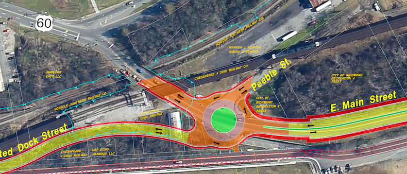
Perhaps the most arresting sentence? East Main Street will be closed January 2017 to August 2017.
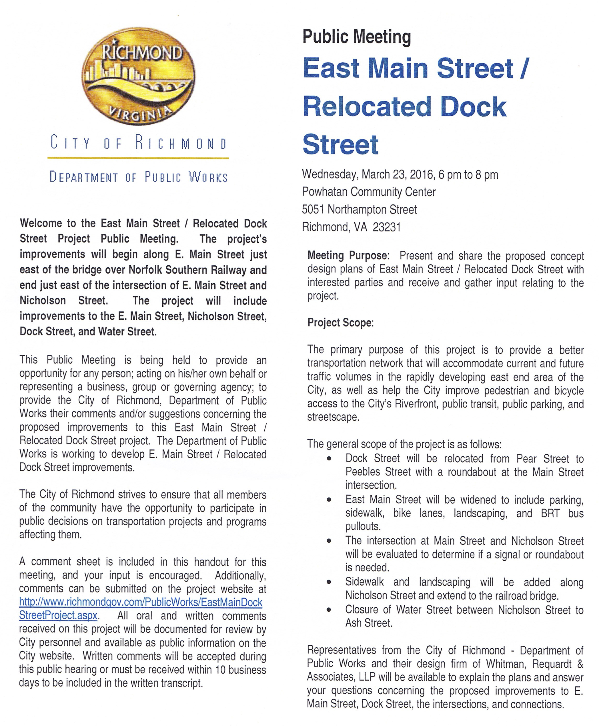
The city’s page for the project describes it thusly:
This project’s primary purpose is to provide a better transportation network to accommodate current and future traffic volumes in the rapidly developing east end area of the city, as well as improve pedestrian and bicycle access to the city’s riverfront, public transit, public parking, and streetscape.
- Dock Street will be relocated from Pear Street to Peebles Street with a roundabout at the Main Street intersection.
- East Main Street will be widened to include parking, sidewalk, bike lanes, landscaping, and BRT bus pullouts.
- The intersection at Main Street and Nicholson Street will be evaluated to determine if a signal or roundabout is needed.
- Sidewalk and landscaping will be added along Nicholson Street and extend to the railroad bridge.
- Closure of Water Street between Nicholson Street to Ash Street.
[sep]

[sep]
[sep]

[sep]

[sep]

34 comments
I’m sorry, you lost me at ‘east Main Street will be closed’ for 6 months. WTF?
Doug Kipps liked this on Facebook.
@chpn as someone who drives home daily through there, this plan looks like a train wreck.
Roundabouts suck, all they do is create confusion, delays and accidents
Doesn’t really sound like public feedback ort of meeting.
ENOUGH ROUNDABOUTS RICHMOND!!!! ENOUGH!!!! You put them everywhere except where they need to be!
Also thanks John for sharing!
Sure looks like a waste of $7M. Might as well build a ballpark there while they’re at it.
“Transit Shelter”? They look a bit like gallows.
Jacob Nieding liked this on Facebook.
Entering the new Dock Street from Main heading west will be crazy!
All of these roundabouts ?.. But can’t fix the schools ?….
Roundabouts actually make traffic flow better and reduce the number of accidents.
Mark Kronenthal liked this on Facebook.
Note the relocation of Dock Street in the lower left hand corner of the map.
Is this being done to help the Echo Harbor developers with their plans for multi story office towers?
Yael Kern liked this on Facebook.
Chris Amey liked this on Facebook.
Catherine Graham Illian liked this on Facebook.
This will end up looking really nice!
Actually, roundabouts are statistically shown to reduce accidents, especially fatal ones such as t-bones. I believe it’s shitty drivers that cause accidents. If you’re paying attention they will actually smooth the flow of traffic. They’re also more bike friendly.
IDK…I’m from NJ. Long time roundabout hater, here. I hate hate hate those things. But eastward expansion is inevitable and we have to look 30 years down the road (no pun intended). And what type of closures are we talking about, lane closures, resurfacing from 9pm- 6am? Surely this can get done without cutting off total access.
I think they’re referring to E. Main St. between Williamsburg Ave. and Nicholson St. as the section that’s being closed. Why would they close the rest of E. Main St.? That wouldn’t make any sense based on the description of the project area.
I think they better put money into the schools and higher better teachers FIRST.
In the project description it states that the road closure is due to the already planned VDOT replacement of the Rt. 5 bridge over the railroad tracks. So what they are doing is coordinating the construction work on E. Main street with that work so that there is only one period of road closures instead of creating a whole second period of road closures for this project. And yes, they’re closing it between W’burg and Nicholson, with a detour on Dock/Water St. and Nicholson.
Andrea Bailey liked this on Facebook.
I am wondering what is going to happen when the traffic circle they are planning at Ash/Peebles/rerouted Dock Street/E. Main Street is put in. If traffic is headed west in the morning, what happens when the light at Main and Williamsburg turns red and traffic stops? Does it back up into the traffic circle? If I am traveling west on E. Main I need to go 270 degrees around the traffic circle to get to the new Dock Street…if traffic is flowing east on Main after it splits from Williamsburg, will my stopping to wait for traffic cause a backup? Cars FLY east on Main after it splits from Williamsburg, I can’t see this being a good solution…
thanks John for all your work! and thanks Ann for the gallows joke. i guess to jump on the roundabouts…ive driven through many in several states. they work when its a combo of clear marked driving flow and quality drivers. period. some here in richmond are perfect. some…well…
Roundabouts beat 4 way stops any day. Those bike lanes look scary, especially when you are riding between a bus and traffic. Will Richmond ever learn how to design and implement protected bike lanes that separate bikes from traffic?
#19… Great point… had me laughing… this is an awful idea…
Linda Mathers Kronenthal liked this on Facebook.
There are good aspects to their proposal including bike lanes, on street parking, more room for parks and riverfront activity, but the roundabout must be designed right to not just smooth traffic but to also slow it and allow pedestrians to safely cross to and from the riverfront. BUT what concerns me is the city’s failure to consult far earlier in the process and to share the big picture – read on for surprises…
1) They’ve been studying this for 2-3 years and failed to share information or allow public participation. This meeting feels like a check-the-box exercise when the design decisions have already been made. The meeting was also designed to prevent broader discussion and sharing of knowledge since there was no formal presentation with q/a.
2) The plan doesn’t include the planning/design details we need for making Main and Williamsburg safer to cross from Church Hill or Fulton.
3) The plan presumes Williamsburg will become Route 5, using Option 2 from the old Route 5 study to built a four lane elevated highway along Old Osborne Turnpike from Williamsburg over the CSX tracks to the fork in Route 5 in Marion Hill. You wouldn’t know this if you didn’t spot the 10 copies of the Option 2 chapter from that study out on a table AND asked the engineers what they planned for Wiliamsburg.
4) This redesign of Main and Dock appears intended to make the waterfront more inviting for development while moving the traffic to Williamsburg, but it may also make Williamsburg harder to cross for Fulton residents. (Proposal is to keep four lanes and add a protected bike lane, and I think an improved median). (We really need to be able to understand what will happen to traffic volumes and flow with their proposal).
5) This is the second meeting where the city only wants to talk about a piece of the East End. The last one, they only wanted to talk about the Lehigh Cement park and the Sugar Pad in front of Intermediate Terminal. But we need the big picture for all of the parcels, streets, parks, trails etc.and a real opportunity for the public to participate in planning. I’ll share more on this in my next comment. Sorry to go on so long…
CHA members have repeatedly asked for a comprehensive East End riverfront planning process instead of looking piecemeal at a transportation section, the small Lehigh Cement park conversion, etc. The plan should look along all of Dock, Echo Harbor, the development sites on Pear Street, Fulton Gas Works, Gillies Creek Trails, Fulton, balancing riverfront parkland and development, etc
Many Church Hill residents and state preservation groups would like to see the Echo Harbor site purchased as a park, but the city won’t even allow the site to be discussed. Development along a river can be great, but at that site the need to be two stories about the flood plain has resulted in the city approving three office buildings on top of a 900 foot long two-story parking garage, with buildings at 7, 9, and 11 stories. The result would be a wall of buildings in the foreground of the amazing views from Libby Hill Park, views that are a big economic asset to the city attracting tourists, weddings, photo shoots, festivals etc. There isn’t a market for office buildings here (or anywhere at the moment), but the city is bending over backwards to make some project viable — by spending staff time to assist in the moving of the Combined Sewer Overflow pipe AND now in this transportation plan providing a raised roadway at the roundabout that will allow the project the fire/rescue/safety access above the floodplain that would allow the owners to convert to more viable residential use. Instead, imagine what a large connected park between the “Low-Line”, Shiplock, and the Stone Bistro could mean for waterfront activity — including walking, biking, fishing, picnics, and team sports. Whether or not you agree with a particular idea, shouldn’t we look at the East End riverfront in a comprehensive way to ensure a range of creative ideas are on the table?
Hey everyone – the link in the article above has a comment form on the City’s website – http://www.richmondgov.com/PublicWorks/EastMainDockStreetProject.aspx.
Print it, fill it out and mail it in. If we all do it, we can influence this project. We may not all agree, but perhaps they’ll hear us and make some changes.
@23/24: that was a main takeaway I had from the “presentation” the other night–there isn’t a MASTER master plan, there are only mini-master plans that deal with very specific issues related to traffic, waterfront development, public access, transportation, etc. The city seems to have no idea how to take a step back and conduct and oversee multiple intersecting issues. The reps the other night couldn’t explain how people getting off the buses at the Pulse transit area or parking on E. Main Street would walk down to the Capital Trail–they aren’t considering them as connected??? There is a steepish embankment there, are you just encouraging people to get off the bus, hop a fence, and have them descent to the trail that way? Or walk a whole city block and then down and around? And how will people cross at Main and Nicholson if they want to walk from Stone Brewing to the Capital Trail? I could go on, but my point is that they aren’t weaving all the elements and issues together, they are letting them exist separately, and at great risk of doing a poor job of it all. So frustrating.
As far as Echo Harbor–who owns it now? One of the property owners has moved out of state, not sure where the development llc is on moving ahead with the business park thing. Why won’t the city buy it?? Ridiculous.