
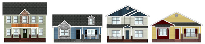
All are invited to the ribbon cutting ceremony on August 19 at 4721 Louisiana Street for the Villas at Rocketts Landing, billed as “Virginia’s First Solar Community”. The ceremony will start at 11:30 AM, with tours from 12:00 – 1:30 PM.
- Refreshments Served
- Three Model homes available for inspection
- Introducing a balanced approach combining advanced building science practices with onsite solar electric generation that is a first in Virginia. These next generation solar homes combine high-efficiency performance with an affordable price tag, while lower energy bills make them more affordable for the customer to own.
- Affordably priced from $222,000 to $249,000
Villas at Rocketts Landing is planned to be a community of 45 single family homes immediately north of Williamsburg Road at Orleans.
[sep]

45 comments
I still think it should be a crime the way they cut down that grove of OLD trees to cram these boring houses in next to each other. They should have worked with and around some of the trees.
BTW, shade trees cut down on energy bills too!
Shelly Wilkie liked this on Facebook.
Emily Klinedinst liked this on Facebook.
Chrissy Schlegel liked this on Facebook.
Leslie Perucci liked this on Facebook.
Stacie Wheeler liked this on Facebook.
RT @chpn: Villas at Rocketts Landing will be “Virginia’a First Solar Community” http://t.co/mtNPckhRGQ
It looks like the houses are actually that close together too
Kyle Cortez liked this on Facebook.
Laurie Polizzi liked this on Facebook.
Chelsea Harnish liked this on Facebook.
Kim Leonard liked this on Facebook.
Courtney Belden Marsh liked this on Facebook.
I wonder when the name changed because that’s not what it’s called according to city records… I’ll recheck when their site isn’t down again…
Bee Saybes liked this on Facebook.
Belinda Viers liked this on Facebook.
Mary-Courtney Kaplan Hunroe liked this on Facebook.
RT @chpn: Villas at Rocketts Landing will be “Virginia’a First Solar Community” http://t.co/yAVxwaNPL2
Shannon Campbell Ward liked this on Facebook.
Corey Lane liked this on Facebook.
Ashley Dawn Goodmundson liked this on Facebook.
Dave Gorman liked this on Facebook.
Bruno Welsh liked this on Facebook.
My understanding is that this used to be land owned by the city. I am not a tree hugger by any means, but wish they had made some green preservation a condition of the sale. A grove of old growth oaks were felled for this unininspired neigborhood.
Jen Sinclair liked this on Facebook.
Lucas Hall liked this on Facebook.
Katarina S H Pace liked this on Facebook.
Jennifer Greiner liked this on Facebook.
Jennifer Bradford liked this on Facebook.
According to the assessor’s site, it’s still Fulton Village. Until that changes, I am not changing my map.
I also object to the use of Rocketts Landing outside of the Rocketts Landing development AND Rocketts itself.
@Cadeho – I’ve seen old maps (here & here are 2) that label that area “Rocketts”
That area is part of historic Rocketts. That name way predated Fulton Village!
Rainie Bishop liked this on Facebook.
The label “Rocketts” on those maps is written next to the blocks it represented. It does not apply to the entire area. Both of those maps were not drawn to scale or even accurately to the actual grid as they are representational. What was labelled as Rocketts in those maps were Lester’s (and others) Addition, Nicholson’s Addition, and Port Mayo. Micajah Bates’ 1835 map has “Rocketts warehouse” on lot 170 near today’s intersection of Main St. and Williamsburg Ave. The Woodward House is said to be the last structure from Rocketts. That area was laid out as early as 1812 being a part of Wiltshire E. Lewis’ estate. Rocketts is also pointed out in “General Lee’s City” as being below Libby Hill on the river which references the Matthew Brady photograph of Rocketts. I am aware of Rockett’s ferry in the 1700s. The landing and port only applied to what was on and close to the river.
The area east of what would be the old Williamsburg Avenue was a part of another subdivision. It is represented by numbered blocks on F. W. Beers’ 1877 and T. Crawford, Redd & Brother’s 1901 maps of Richmond and Henrico. I admit I still need to research that subdivision’s name as well as a curious feature on the 1877 map which is the “line of Mt. Erin and Fulton.” It appears to outline a property. I will also need to research the properties of Baldwin and Ware Rockett to see just what they owned. The Mayos owned Powhatan Seat to the south (Port Mayo was subdivided from that plantation) and the Fultons had Mt. Erin to the east. Those two places were existing at the time of those maps from 1864 and 1865 and are not represented.
I cannot change the name of this development. I was pointing out how has always been Fulton Village since the subdivision was laid out. This is the last phase of it. I saw the sketch of this phase in 2006 when I spoke to its developer as I asked that the original grid be preserved. The city’s assessor legally has it as Fulton Village and I was stating I will not change the name on my map until it is changed by the city. I have never seen a subdivision be rolled out in phases and the last phase be renamed at the last moment. Both are by the same company and perhaps the name did change and it is a separate subdivision, but until the city updates it officially and legally, my map won’t change.
Aileen Rivera liked this on Facebook.
Marin Brünnhilde Blythe liked this on Facebook.
17th Street Farmers’ Market liked this on Facebook.
Megan Charneco liked this on Facebook.
Solar subdivision rises in the East End
http://www.richmondbizsense.com/2014/08/18/solar-subdivision-rises-in-the-east-end/
Virginia’s first solar community is actually Garden Atriums in Poquoson started in 2002. Not only are they solar, they are very close to net zero, including using rain water for all household water and using permeable paving throughout and communal vegetable gardening.
Wow this is very wonderful. The first affordable solar community in VA, 45 houses; Thats a community.
Congrats to the developer and company that installed the solar systems. Its a great gold star for Virginia. Every Virginia should be very proud of this.
The 45 homes are going to be the best! The area is coming back and the area is going to be prime!! Stone Brewery and much more!!
My daughter and her family just moved into this new award winning community. They have a well constructed home with many custom features. The builder is intent on building an energy efficient community that is close to the city and beautiful. Anyone who wants to get into an affordable solar home will want to check this community out.
There were communities called Solar I, Solar II and Solar III in Chesterfield in the 80s. Why would they call this the first? Maybe the first in the City of Richmond, but not in the state.