
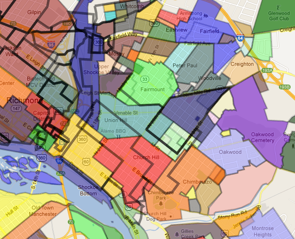
Cameron Holmes has put together an amazing map that digs into the neighborhoods and subdivisions in Richmond.
In his own words:
Since childhood, I have had an interest in the history of my family’s neighborhood, Woodville. In the early 90s, my aunt gave me a copy of a rough draft of a city neighborhood study from a co-worker who knew she was from Woodville. The study divided the East End without the Fulton area into 22 study areas based on the neighborhoods. Woodville was study area 1. Previous to reading that study, like a lot of people, I grouped Fairmount, Union Hill, Oakwood, Chimborazo, etc into one neighborhood.
Also during the 90s, my collection of books on Richmond started to grow and focus more on neighborhoods with Church Hill: The St. John’s Church Historic District, Richmond’s Fan District, and Old Richmond Neighborhoods. From those books, I learned more details about the East End neighborhoods and learned of subdivisions in the West End.
In college, my senior research project was the history of Woodville and during my research at the Richmond and Henrico courthouses, I discovered smaller neighborhoods in and around Woodville while looking at the deeds and plat maps. This contrasted with the city study map which I had used in determining the boundaries of Woodville. I made a few maps showing Woodville and its surrounding neighborhoods based off my new-found information. After the paper and college I said I would continue my research on Woodville and expand it to other areas of the city; however, I have not gone back to the courthouses to do the research I had wanted as of yet.
By 2004, I had found the city’s official neighborhoods map and was disgusted with what I saw. My neighborhood of Woodville was in the wrong place. Then I looked and found the boundaries for everything was incorrect, neighborhoods were omitted, and places had names that seemed to be made up and never existed. I wanted to correct this error. I had found Henrico’s map on its website in brilliant detail. Every subdivision was labeled even if it was one or two parcels. I wondered why couldn’t Richmond have its own true map?
In 2006, I came across the city’s GIS map of the city. I printed them out with hopes of taking some of the addresses and going down to the courthouses to find the plat maps or anything I could find. I started with the entire East End. I compiled a list of addresses of some parcels of interest, but before I could finish, the site went down and was redesigned to basically what it is today. When the city’s new parcel map was made available in 2007, I printed the entire city and discovered that I could read the parcel info. I went through practically every street and address and gathered the legal description associated with them. Those were the names of the subdivisions.
I sorted through the list of addresses and neighborhood names and plotted them on the parcel map. From there, I printed out street map from the city and drew on it the boundaries of the neighborhoods and subdivisions. I had also found many plat maps thanks to Henrico uploading them to their site and I had come in possession of many maps and more books on Richmond that included old maps which had the names of places I had discovered using the city’s own information.
A friend let me know that Google Maps had started to allow for people to make their own maps. I took advantage of that and started to input the information from my maps. There are some subdivisions that I need to confirm the exact boundaries or names because some descriptions only had block and lot numbers and no other information. I did yield to some modern maps of the city and used names such as Church Hill North, Monroe and Jackson Wards (neither of which is an official name and are from one subdivision), City Center, Shockoe Bottom, etc but added later outlines of the original subdivisions to this map.
I have wanted to show this map to the city and to its residents in order to have the city’s map corrected and to educate the public. I grew tired of the news getting areas wrong and places like Google using the city’s incorrect map to label places on its map. The very thing I was using while making my map started to use the incorrect information. I also wanted to let those in the city government know before they started erecting neighborhood signs in the wrong places or using wrong names. Everyone should know where they live. If you go to the counties, everyone knows their subdivisions exactly. The city is made up of many subdivisions and a lot of people don’t know where they live. Those in the West End annexed in 1942 and Southside annexed in 1970 pretty much know where they live and the city has some of their subdivisions correct.
What I find amazing is that the names of many of Richmond’s older neighborhoods had remained known and in use since at least the early 1800s until somewhere along the line, someone started calling them by other names. The deeds and older residents could tell you the real names. Legally, the correct names are in the deeds and as long as they have not been changed, those names still stand. A lot of people don’t and won’t care about such issues. I’ve been told by someone at the city that letting people know the truth would divide people and neighborhoods and we’d have more places with rivalries. I really doubt that. People should have the correct information available to them at all times. I think it’s time for people to become reacquainted with where they actually live.
There’s still more work to do on the map, but I have enough to present. There’s time to fine-tune and as the city grows and adds more subdivisions, it’ll be updated. I am open to corrections or additions.
22 comments
RT @chpn: Richmond’s true map – Cameron Holmes has put together an amazing map that digs into the neighborhoods… http://t.co/XdVhi0CR …
@HillsHeights check out this cool map featured on @chpn it also shows H&H neighborhoods http://t.co/PArdp5Po
RT @chpn: Richmond’s true map – Cameron Holmes has put together an amazing map that digs into the neighborhoods… http://t.co/XdVhi0CR …
RT @chpn: Richmond’s true map – Cameron Holmes has put together an amazing map that digs into the neighborhoods… http://t.co/XdVhi0CR …
RT @chpn: Richmond’s true map – Cameron Holmes has put together an amazing map that digs into the neighborhoods… http://t.co/XdVhi0CR …
Interesting map of my hometown, Richmond: http://t.co/OEHFLRoi
This is doopppe #GIS #MAPS RT @MRKMRDR: http://t.co/oWPQ1svW @DougFRSH757
RT @chpn: Richmond’s true map – Cameron Holmes has put together an amazing map that digs into the neighborhoods… http://t.co/XdVhi0CR …
Thank you! What a lot of work you’ve done that can be of benefit to anyone interested.
This map shows me being in Union Hill. There isn’t any Church Hill North on it, but that is what the City officially calls my neighborhood. It is a good looking map, but seems inconsistent with what I thought I knew about the area, although my sources easily could have been wrong.
Nevermind, viewed the map before reading the story to go along with it. He clearly states this is in disagreement with the City’s map. I appreciate his work, but mapping and naming of neighborhoods will never be an issue where it is corrected once and for all, the lines/names will always be disputed, especially a place as historic and changing as Richmond.
Dude I live on Stonewall by 45th and you have no neighborhood here! We are adrift in namelessness on the south side. Send beer fast!
@ Rodney Dyer, I am sorry! You would be from the area that caused me some frustration when I was doing that area! The information at Richmond’s parcel mapper doesn’t list a name for a group of lots. I have wondered if they are a part of Anderson. The blank areas have addresses on a list for me to research at the courthouse whenever I get to go again. If you have access to the deed, let me know what it says. That is another reason why I wanted to show the map. I am open to suggestions to improve it. On the Henrico and Chesterfield maps there are a lot of places that didn’t belong to a proper subdivision. I think the city has a lot of the same.
Bret, even though we are considered Church Hill North by the historic districts, it is Church Hill in whole. There has always been a division line NOB (North of Broad) and SOB (South of Broad and in the days of attempted gentrification the SOB had a different meaning). But the map seems to be missing some area in the dark purple east of Oakwood and the light green area north of Church Hill and east of Chimborazo is considered Shed Town but not mentioned.
Sorry, got my East and West mixed up but you know what I am saying 🙂
I’m confused, Eric. Shedtown is there. What’s missing?
Cadeho,
Please contact me via cityhallreview.com regarding old city maps.
Thanks,
C. Wayne Taylor
Interesting. On every map I’ve seen previously, my house is located in Chimborazo. On this map, my house is (barely) located in Church Hill.
RT @chpn: Richmond’s true map – Cameron Holmes has put together an amazing map that digs into the neighborhoods… http://t.co/XdVhi0CR …
Every Richmonder should see this: MRT @chpn Richmond’s true map by Cameron Holmes http://t.co/KNqCtpX2 #RVA
after seeing this map I tried to use assessor’s data to do an ‘official’ version of subdivisions using legal descriptions. http://bit.ly/I4t57W
My hat is well and high off to Cameron for his diligent effort. How grand it is to see Boulevard Residential Park (which sounds like a place you’d send someone who was especially nervous to rest). I didn’t learn of the true name of where I live until about two years ago. BRP, represent!