

Civil War Richmond is “an online research project designed to collect documents, photographs, and maps pertaining to Richmond, Virginia, during the Civil War” that has, among other things, a collection of maps of Richmond from around the time of the Civil War.
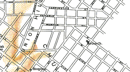
The map above (source) is described as a “map of Richmond from the Official Records Atlas, Plate LXXXIX, #2. Prepared in 1864 by A. D. Bache for the U. S. Coast Survey.” Civil War Richmond goes on to point out that “this map is flawed in two places – the locations of the Jefferson Davis House and of Libby Prison are both incorrect. The map itself is copied from an 1853 map of the city entitled “Smith’s Map of Henrico County.” Whomever prepared the map for the Union army obviously added these Civil War era features, and got them wrong.”
Interesting changes since then include the reworking of the streets around Jefferson and Chimborazo Parks, and the inclusion of the lettered streets north of Carrington (an area then part of Henrico County).
9 comments
I’ve never though that particular map accurate. There were other incorrect maps made of Richmond during the Civil War along with street names that didn’t exist. The most accurate map that I absolutely love is the Mitchie Map from 1867. I’ve gotten several maps and pictures from mdgorman and have e-mailed him with no reply. I’d love to get my hands on that Mitchie Map because he only used about half of it. I’ll have to find my way to the Valentine some time.
Correction: Michie not Mitchie.
Are you referring to this map below? It is very large so they broke it up into sections yet all of Richmond of 1867 is there as far as I can see.
Eric
http://www.mdgorman.com/Maps/1867_engineers_map_of_richmond.htm
Fifteen or so years ago, a friend of mine found a copy of the Gorman map in the attic of a house on Grace Street. It was in disrepair, had come in four sheets, and was taped together. I took it to Corporate Frames and had it cleaned and mounted on foam core, and it stayed in my office at The Martin Agency for 10 years, before I retired. Told many a guest about its origin. Sadly, didn’t have space for it so it stayed behind when I quit work.
Yes Eric. I love that thing.
Tom is it still there? Just march back in and get it! Say oops I forgot, I left this here.
Cadeho..
It is a valuable map indeed and gives one a perspective of Church Hill before the trolley system graded the streets flat in the 1880s and developers cut through the hills. You will note that one hill (Libby?) runs up to the corner of 28th and Broad where the Hill Cafe is now so no building was there and Broad did not run straight through for several blocks in that area. There was a cut through street to go around that hill area. Then Jefferson or Union ran up to 25th Street and again the same thing – blocks zigzag around it.
One of the trolley pictures that John posted a link to some time ago in his photo collection gives an example and shows 21st Street and Marshall and you can clearly see a very large ‘U’ shape cut out of the hill to make 21st run through it to Broad and the other side can be seen but now gone and houses sit there.
Eric
Query: How did “Church Hill” in East Richmond get its name?
#7, Not exactly sure, but I believe it’s because of St. John’s Church and being on the hill. Used to be called Richmond Hill.
It was also called Indian Hill at one time.