
The RTD os reporting a proposal for the Lehigh Cement Company site:
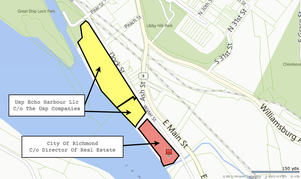
USP Echo Harbour LLC submitted a plan to the Richmond Department of Planning and Development Review on Tuesday to build almost 378,000 square feet of office space in three buildings on 5.2 acres east of Great Shiplock Park in the city’s East End. […]
Unlike previous development proposals, the new plan would not require rezoning or a special-use permit to be built on the now-vacant property, zoned M-2 for heavy industry, as it was previously used by Tarmac, a concrete and building materials company.
Dig into the “Echo Harbor” archives for backstory, this goes back to at least 2006.
39 comments
John,
On July on 17, 2012 you reported that the City had purchased this piece of property. Who owns it now?
If the same developer as Echo Harbor is involved, then the front man is a local named Ross but financial backing is “Moonie money”
The Times-Dispatch article linked to in that post (HERE: http://www.timesdispatch.com/agreement-between-richmond-cement-company-clears-way-for-bike-trail/article_c1266c83-cdcb-5722-a5d0-e2fe36a111af.html) says:
I’ve swapped out the image above to be less confusing.
This should be a park .,Not a brick strip mall that takes over river access , it would be such a shame to lose that stretch of land to developers .
This sounds pretty awful. That said, when the developer said to the neighborhood a few years ago that if the neighborhood wouldn’t work with him on his first choice with objectionable height but pretty neat river access bells and whistles, he would do something cheaper and by-right, the neighborhood screamed “false choice!” This is a lesson for us that the alternative is NOT a false choice.
One of Rachael Flynn’s great comments was that this is what that property should be:
http://www.charlestonparksconservancy.org/our_parks/view_park/waterfront_park/
So in fighting a mixed use development that would provide access to the river and jobs for our neighbors, we are left with an office park that belongs in Innsbrook? Great play, NIMBYs.
I would much prefer this land to be developed than be a park. It is directly next to Great Ship Lock park so additional public space would be redundant and likely under used like so many in Richmond. The development near the park will form an urban gateway to the park and add density to Great Ship Lock’s adjacent areas. The park and neighborhood will be safer as a result of this project. It is also a good opportunity to reuse a vacant urban brown field and concentrate development downtown rather than continuing sprawl. For the river, the neighborhood, and the city at large, this is a good project. I only wish its idealism hadn’t been tempered by people afraid of change.
Personally, I prefer a park at the location. But if the developers and the city are hell-bent on buildings, why not just reduce the height of the planned buildings so they don’t interfere with the view? That’s been the crux of the divide on this issue. Less leasbale space=less future money in their pockets, but it’s a compromise that might satisfy both camps, and most importantly, leave the view intact for the currently living and future generations.
Buildings with 4 or 5 stories (lower than the current silo, with rooftop restaurants or elevated park/gardens could work.
At least until the inevitable ‘flood of the century’ wiped them out. Which is a reality that should predicate all others in considering an expensive development of any kind…
Well said #6. I think a good lesson here is to be careful not to draw such a firm line in the sand. While details of the plan haven’t been released yet, it seems to me working to achieve a compromise with the earlier designs would’ve been a much better alternative than what is proposed now. It also makes me wonder how the proposal for the Pear Street site will evolve in light of this situation.
#6 & #7 are spot on.
#8–I would assume that the heights the developers are proposing are not arbitrary. I would guess that those heights achieve what they believe to be enough leasable space to make the project financially worthwhile. The fixed site preparation and base structural costs of 5 stories vs 8 stories are probably fairly similar in terms of excavation, footings and foundations. More floors allow them to more efficiently amortize those costs and may be need to amortize them profitably. So while 4 or 5 stories might work wonderfully for you, they may not work at all for the people investing in this development.
In the end, it’s their land and it looks to be a by-right project. That means that if they have the financing, this is likely to happen. Once again the pursuit of perfection was the enemy of the good. Maybe this will wake some people up to realizing that landowners and business people have some rights to do with their land as they will within the law and it is better to work with them to come up with a solution where everyone gets 80% of what they want than to draw lines in the sand and get nothing. I think the people that fought this are going to end up getting just that for their effort–nothing.
Now our City’s cultural heritage is being literally sold down the river. Richmonds Master Plan for Church Hill: Block out the View and build more ugly office buildings. Very prudent planning by our city fathers. “The ends justified the means. Sit down citizen this is for our own good.” Now that the view is ruined lets rename Richmond- Carrier or Fedders- named for the the view of the massive air handling systems on the roofs of these structures.
I disagree that an office park (with retail space) is bad. We seem to have tons of apartments/condos – I say more professional jobs (say in an office park) and retail are great! It’s still essentially “mixed-use” because it’s surrounded by housing. We who live here need jobs to go to not more neighbors. It’s all fine and dandy to have lots of people live in the city, but if you have to drive to Innsbrook to work, that sucks.
Be careful when you dig your heals in and insist that what you want is the only compromise position. Now the developer has proposed a project that only needs to meet sound engineering construction and has a “by right” use.
At least when the Special Use permit process was in play, the neighborhood had some leverage and input. That’s not the case anymore.
The already approved development of Rocketts on the City side of the corporation line will block more of the downriver view than this will.
@ BAF #10 and Magneto #9 – I think you are right on.
The concept of offices is not inherently flawed but mixed use with residential would have been the best alternative to a park. So what now? How does the neighborhood help make this a good project now? Is there a venue for neighbors to comment on quality of building finishes and design like there would have been in the SUP process? Probably not. Welcome, Innsbrook-upon-James.
#6 – Best comment ever written on this website.
You guys hated what was actually a very tasteful and great project. And now you get Innsbrook on the James!
Top of this photo is what it could have been. Bottom is what you get. Joke’s on YOU!
http://d.pr/i/WLYR
Guess that is what happens when you play a zero-sum game with people that are willing to take it all the way down to zero.
Any chance this influences the CHA to be more cooperative on Pear Street? Will Buzzy’s neighbors become more willing to work with Bob? Or will this just be a wasted lesson?
#15 Ugh! What an object lesson. I hope we don’t have to reap this reward. Wasn’t this possibility clear to the “preservationists” when fighting the previous iteration? I use quotes because so far as I know the “view that named Richmond”, taken now as gospel, is pure conjecture based on a picture taken by a Richmond family traveling in England. It was published about 8 years ago and it caught on. I wish I could find the link to their blog. It’s a nice view, not a pristine view, but you can take the historic argument off the table.
So they called your bluff. The rest of the city should not have to pay for your mistake, but maybe we will. You and your allies on City Council drove us into this ditch. What a shame.
http://downtownrichmond.blogspot.com/2009/06/richmond-on-james-vs-richmond-on-thames.html
Can they preserve the view and still have ground level use of their property? It truly is an awesome view that should be preserved for future generations. Someone above mentioned Charleston and I recently visited that city and have to say they have done a great job with preserving their natural and architectural treasures. Go see Charleston they did everything right. Lately our Mayor and Council are not when it comes to working with and enhancing our best features.
I’ve always thought an aquarium would be nice for that land and keep it low so that the horizon is never broken and one can still see across the river. It seems no one has ever done any kind of study to show those heights. Raise cranes or something. But the view is more than the bend as the picture in the article shows.
When can we expect the NIMBYs to start running their commercials against this? Will their buy against Buzzy finish before these ads start?
@#10 While you may be correct in regard to the amortization re: height and square footage, the main point of the fight against Echo Harbour and this new development are preserving the viewshed. They are proposing at least one 133′ tall building. The Echo Harbor plans called for 12 stories, which is about 120′, thus those fighting against the development will not have changed their perspective that it’s simply too tall. The developers are not trying to get 80% of what they want, they are (figuratively) trying to get 110% if in fact these buildings are taller than the Echo Harbor plans.
Four or five stories isn’t ‘wonderful’ for me, it’s an attempt at a compromise that would allow both sides of the argument to find common ground. If the developers cared what anyone else had to say, where is a compromise proposal with shorter buildings? Rocketts Landing has been a successful development and all of those buildings are six (or so) stories or less, and they don’t block anybody’s view.
And while the developers do own some of the land (the Lehigh property is owned by the city), this particular parcel, adjacent to the ‘public’ river and its viewshed are valuable to and ‘owned’ by all of us, so our opinions matter even in the face of ‘business interests.’
Does anybody know the height if the silos currently on the site? This would give some perspective as to what they are planning. The silos are an eyesore. Anything put in their place should be shorter than the silos.
And again, (Iast, but certainly not least) there’s that pesky flood problem…
Here is a link to photos of the area flooding in 2010.
https://chpn.net/news/2010/01/28/flooding-at-echo-harbor-site_11820/
Does anyone know how tall the concrete silos are? Isn’t the concrete property owned by the city so the proposed development will be west of that so not really affecting “the view” as seen in the photo.
The City is developing the Lehigh silos property into a park as part of the Capital Trail buld out. The silos will come down. The Echo Harbor project is on the adjacent parcel.
Using my handy-dandy GIS tools at work, I measure the silos at about 137 feet from their base along Wharf Street to their highest point, which is some sort of rectangular apparatus on top of one of the silos.
Pave over history just like several years ago in Church Hill like they paved over the beautiful cobble stone streets. Leave the decisions to people many of whom aren’t from Richmond to change our cultural outlook. Take the power out of the peoples hands. Nearsightedness reigns supreme. Divide and conquer the oldest trick in the book.
Spacecat: “and its viewshed are valuable to and ‘owned’ by all of us, so our opinions matter ”
By our opinions, I take it you also mean people who disagree with you and believe something could be built that would serve the city, the developers, bring new jobs, shops and residents, provide access to the river and maybe help pay for the new park next door.
The river is a valuable asset that belongs to all the citizens of Richmond, most of whom have never seen this view.
It seems to me like there needs to be a few breaths taken. The project will take place towards the west side of the land that is lawfully allowed to be developed. This means that he “historic” view is not going to be impacted, which is the view towards the east. In fact, while looking south towards the project (in the direction of the water treatment plant) and once you take into account the proposed heights of the buildings, the elevation of the hill, and the 40′ 60′ tall trees in between the two spots, you might see the roof of one building. That being said, if they put a green roof on that building, it will blend in. (I figured this out by not only standing on the hill, but also by using Google Earth’s terrain feature to figure out the height of the hill)
I also noticed from the article that Mr. Mills was mentioned as working on the project. Doing my due diligence on him shows that his architecture firm has no ties to any of the atrocities we see at Innsbrook and has actually done quite a few things around town that my family and I love, like Movieland and Cary Court in Carytown. Hell, there are even pictures of them cleaning up Great Shiplock park. (until recently, that place was neglected by the city)
I just want everyone to calm down and look at the facts they have given us, before grabbing the pitchforks. We haven’t seen what they have come up with yet, but we do know a few key things that work in our favor. Lots of park space on the proposed site and what has already been outlined in red (keep in mind the cap to cap trail will have to go through there and there are easement issues to the waterfront to consider), The heights of the buildings are barely above tree level from the top of the hill (if at all), and they are not building towards the view to the east of the James. I am waiting until I see more, because screaming blindly doesn’t get us anywhere.
Lastly, google search “view of historic rocketts landing” and then look at the famous photo taken in 1860, it looks like a hell scape. That’s our historic view, so lets keep that in mind. We’ve come so far from there, it’s easy to forget.
@22: The viewshed may belong to all of us (although I would love to see a legal citation that backs it up), but the land belongs to the developer and the zoning is in place. I think that trumps the view shed we all own.
But as I have posted in other threads on here about other projects, there is a simple solution for you to get what you want. Raise the money to buy the land and make the developer an offer. If he takes it, you can be certain your viewshed is preserved. If not, he apparently can work his will on the property within the limits of its zoning designation. Should he need a variance from that, the City may choose to weigh your input at that time.
In communities all over the country people who feel strongly about determining the outcome of projects or want to preserve something the way they see fit, find ways to raise the money and take control of the situation. That would be the perfect solution for you to preserve your viewshed here.
@#28 Thank you for your voice of reason and analysis. If you are correct about Mr. Mills, then perhaps he does have concern for the effect the final product will have on the community.
@#27 Your second paragraph is exactly what I mean.
@#29. I’m not anti-development as you seem to think, I simply don’t see why a compromise on the height of the buildings isn’t a viable strategy for people on both sides of the issue. The opinions of the developers are certainly valuable and worth listening to as they are trying to take what has been an unkempt and fenced lot and turning it into something more useful for themselves, the city and hopefully the populace. But the opinions of the populace DO matter. Ownership of a piece of land is not carte blanche to do as one pleases (morally and aesthetically speaking), even within the strictures of the zoning, that’s why there are architectural reviews and environmental studies, for example. On a piece of land as contentious and seemingly prized as this, is it wrong to solicit and consider the opinions of those who will have to live with the results? If they do it right, perhaps the citizens will respect them and welcome them when another development opportunity arises in the neighborhood. It doesn’t have to be an ‘us vs. them’ situation.
As an illustration, let me take this discussion into the the realm of the absurd: would you be OK with say, a nuclear power plant there? A theme park with rollercoasters? A Walmart? A 20-story structure? Where do you draw your line?
In this case, I simply draw mine at buildings that are too tall because they don’t respect what’s behind them in a historical, cultural and visual context. I’ve made similar comments in regard to the Pear Street development, for similar reasons.
And honestly, the comment sections this website are essentially about opinions (and a great way for the community to discuss differing views on a subject). I have mine, you have yours, and we’re all entitled to them. I’m sure the developers aren’t reading this and worrying about what littlel-old-me has to say on the subject. If residents of the area are reading this and see some logic in what I’m saying, then I guess my purpose has been served.
@30 – “It doesn’t have to be an ‘us vs. them’ situation.”
Umm, when has it NOT been ‘us vs. them’ when it comes to Church Hill residents?
It’s a shame “working with the developers” for 85% of CH residents mean “my way or the highway” and now the developer is shoving it back in your face.
Echo Harbour was a SOLID vision for the area, bummer.
#30…the issue of compromise here is that the developer probably doesn’t need to compromise. The zoning is in place. Assuming he does his project according to code–architectural specs met and environmental impact issues controlled–there is nothing to compromise about. You have no leverage to seek a compromise.
The time to negotiate a compromise was on Echo Harbor. The developer needed something from the City. To get it, officials would need to assure that voters like you were also considered. When that blew up and they came back with a proposal that complies by right, the need for them to compromise on much of anything went away. The only determinant as to whether or not the buildings are too tall will be what is allowed under the city code for that zoning and that can be accommodated at the site in terms of engineering. The viewshed should not play a role in that process given that set of circumstances otherwise, what is the point of zoning if every project can be subject to conflict even if it is in compliance with the code?
One more thing, #30. You ask where I would draw the line. If zoning allowed for the list of uses you mentioned, then they are allowed. The City has made a determination that what the developer proposes is an appropriate use. The issue has been litigated in that sense. The time to oppose that determination was back when it was made. You can’t just change the rules because someone comes in with a plan that is compliant with those rules and you didn’t see it coming.
Proposed Building Threatens Richmond’s Namesake View
http://www.wric.com/story/23793676/proposed-building-threatens-richmonds-namesake-view
Listen to what your superiors say and be an automaton this is for the greater good. “Laws” are changed all the time to suit who ever is in power. The entire site is packed with buildings, its not pulled all the way to the west of the property. Robert Mills may be named after a historic architect but that is where the similarity ends. His design lacks any human scale, is obtuse and rivals the most generic 1950s office park. Talk about property rights? What about our right to enjoy our cultural heritage without fear that it will be destroyed in favor ill-designed office parks. An educated person from Richmond doesn’t need a degree and a recommendation from a group of anonymous group of architects to figure out where the panorama begins and ends.
http://gothamist.com/2013/10/29/skyscraper_shadows_will_ruin_centra.php
Think it couldn’t happen here?
The article which is being referred to quotes the developer as saying this project is by-right. He fails to add that the city has an easement transversing this property, This easement is a CSO (combined sewage overflow), it is part of a multimillion dollar joint city and federal government project that helps keep raw sewage from washing into the James RIver. It can not be built upon. The developer believes that the city should helpfully dig this up and move it. The developer bought the property with this easement in place. It is not a by right development, permission must be given to move the easement, and someone has to pay for it. The developer believes it should be moved under the road. This city doesn’t have to grant permission for this. This has always been true with this property the city has never yet to my knowledge considered moving the easement. The developer always fails to mention it.
Church Hill Viewer, that is some good and interesting information few know about. To all, if you don’t want this to be developed, start sending emails to the City that you want this to be a park instead, and do it with the same energy with which you commented on both sides of recent other issues. Use your powers for good! Propose viable alternatives!
Well I will say that the developer has the right to build there and I don’t feel that the city need any more park’s. The lesson here is that we had our chances to work with the developers at the beginning and we as always won’t it our way only. When will we learn how to work together just like the ballpark in the bottom there is always enough room for everyone ideals. I bet if we come together we can save the view and also develop the area and have some park space as well. The key is work together!!!